


Adjusted general construction plan of Con Dao, Ba Ria - Vung Tau province to 2045
Thursday, April 28,2022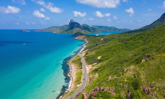
AsemconnectVietnam - To develop tourism in association with conservation and promotion of the values of historical and cultural relics and ecological protection of the natural environment.
Adjusted general construction plan of Con Dao, Ba Ria - Vung Tau province to 2045
1. Scope and scale: The scope of the study and planning covers the entire administrative boundary of Con Dao district, including 16 large and small islands with a total floating land area of about 75.78 km2, surface area. The sea in Con Dao National Park is about 140.00 km2 and the sea around the islands. (The specific area will be determined during the planning process, ensuring consistency with the boundary of the coastal protection corridor and the marine conservation area of Con Dao National Park).
2. Plan period: Short-term period to 2030, long-term period to 2045.
3. Perspectives and goals
a) Opinion
- Conformity with the national development strategy, national sectoral master plans, Southeast region planning and Ba Ria - Vung Tau province planning period 2021 - 2030, vision to 2050.
- To develop tourism in association with conservation and promotion of the values of historical and cultural relics and ecological protection of the natural environment.
- Inheriting and continuing to implement the basic orientations, the contents of the current general plan are still relevant. Effectively exploiting natural conditions and typical ecosystems of Con Dao to develop tourism with identity and attraction, gradually improving the quality of tourism services. Harmonious development between economy and culture - society, environmental protection, climate change adaptation; towards the synchronization between new construction and renovation and embellishment in development.
- To closely combine socio-economic development with the guarantee of national defense and security.
b) Goals
- Adjusted general construction plan of Con Dao in line with the orientation of tourism development, protecting and promoting the value of special national historical relics, exploiting and protecting the national park ecology, towards the development of the national park. Con Dao has become an eco-tourism area of sea, island and culture - history - spirituality with high quality, regional and international characteristics with a synchronous and modern system of technical and material facilities; branded tourism products with high competitiveness.
- Adjusted general construction plan of Con Dao to meet new requirements in the socio-economic development strategy of Ho Chi Minh City and Ba Ria - Vung Tau province; create feasible conditions for synchronous implementation of solutions to solve problems in population development and tourism with the requirements of preserving historical and cultural relics, protecting natural resources and ecology, ensure national security. Towards the development of Con Dao to become a branded, highly competitive tourist area, imbued with historical and cultural characteristics, associated with green and smart urban areas.
- As a basis for the implementation of zoning planning, detailed planning, investment projects and construction management according to the planning.
4. Properties
- It is a cultural, historical and ecological tourist area of national, regional and international stature.
- Being a special national historical relic conservation area, valuable for honoring and educating historical traditions.
- Is an area to preserve the national and international biodiversity of forest and marine ecosystems.
- Having an important position in terms of national defense and security.
5. Preliminary development forecast:
It is expected that the maximum population size by 2030 will reach about 15,000 people; by 2045 will reach about 25,000 people (excluding the population converted from tourists).
Con Dao has a limited land fund, so the size of land for construction and development of residential and tourist areas needs to be considered for effective exploitation. The size of the population, land and tourists should be forecasted on the basis of land fund assessment, technical infrastructure conditions and requirements for environmental protection and sustainable development in Con Dao. (The specific analysis, evaluation and forecast of population, tourist and construction land in each period are studied and proposed during the study of planning projects).
6. Key requirements for general planning adjustment.
a) Overall review of the approved general planning contents:
- Analyze and evaluate the contents of the Con Dao construction master plan approved in 2011 on the basis of the situation and reality of population and tourism development in Con Dao; review the projects and plans in the area that have been formulated and approved; spatial development orientation, land use planning, technical and social infrastructure with current actual development trends.
- Synthesize and make specific statistics on construction investment projects in the area (legal status, scale, nature, implementation progress, ...)
- Evaluate the effectiveness of the planning, management solutions and mobilization of resources for implementation, organizational models for implementation, mechanisms and policies, etc. Identify emerging factors, shortcomings problems in management and implementation.
b) Analysis of the premise, development motivation; forecast development in stages, ensuring conformity with development practice and harmony with requirements of preserving and promoting the value of historical and cultural relics, protecting the natural ecological environment of Con Dao national park towards sustainable development.
c) Study and propose residential - tourism structure, as a basis for proposing adjustment of spatial development orientation, organization of the central system, land use and technical infrastructure in Con Dao in accordance with the requirements of the law, demand for tourism development, protection of relics and natural ecological environment, adaptation to climate change. Proposing solutions on urban design to manage development according to plan.
d) Formulate specific plans for the implementation of the plan, rationally diverging, associated with resources for implementation. Select programs and strategic projects that need to be prioritized for investment with high feasibility, flexibility, meeting development needs in each stage, creating motivation to promote economic development - society in Con Dao.
e) Agree on data, forecasts, development orientations and related contents with the Ba Ria - Vung Tau Provincial Plan for the period of 2021 - 2030, with a vision to 2050, and sectoral and specialized plans other related industries.
7. Research content requirements
a) Analysis and assessment of natural conditions and development status
- Analysis of location and inter-regional relationship: Assessing advantages and limitations of geographical location of Con Dao; analysis of national and regional development orientations and strategies that have an impact on the development of Con Dao. Analyzing the spatial relationship of Con Dao in Ba Ria - Vung Tau province, Ho Chi Minh City and marine space in the Mekong Delta.
- Analysis and assessment of natural features of topography, climate, hydrology, geology..., features of natural ecological landscape, natural resources, cultural resources, history, tourism Con Dao. Assessment of construction land fund on the basis of identifying favorable and unfavorable construction areas and prohibited construction.
- Analyze and evaluate the current state of economy - society - environment through economic indicators and structure; population and labor characteristics; indicators on environment, climate and impacts of climate change on Con Dao.
- Analysis and assessment of spatial development orientation, land use planning, residential structure, tourism: analysis and assessment of the current state of land use. Analysis of the structure and distribution of main functions, landscape structures, gateway areas, central systems, squares, functional areas and the relationship with special national monuments, areas that need protected in Con Dao National Park. Evaluation of the implementation process of the 2011 master plan on spatial orientation, land use, development structure, and technical infrastructure.
- Analyze and evaluate the current status of social infrastructure systems: health care, education, culture, green parks, housing development. Evaluation of the implementation process of the 2011 general plan on organization and development of social infrastructure system.
- Analysis and assessment of tourism development orientation: Number of visitors and structure of tourists, tourism market, tourism products, quality of facilities system, tourism services, spatial organization tourism development,...
- Analyze and evaluate the current status of technical infrastructure and environmental protection systems, including: Traffic, ground elevation and rainwater drainage, energy, lighting, communication, water supply, wastewater drainage, solid waste management and cemeteries, environmental protection... within the scope of planning research. Identify the remaining problems of technical infrastructure system that need to be solved to suit the limited land fund in Con Dao and local customs and practices.
- Reviewing relevant programs, projects, projects and the implementation of the master plan 2011 to present.
- General assessment of the current situation, clarifying the typical elements of Con Dao, proposing key contents to be adjusted in the new planning; identify strengths that need to be exploited as a basis towards the goal of sustainable development.
- Topographic base maps, sources of documents, data and information on the current status must ensure quality, reliability, and have clear sources; ensure the scientificity, sufficient quantity, and sufficient length of data series over time to serve analysis, evaluation and forecast work in the planning process.
b) Determining the nature, goals and motivation of development
- Analyze and evaluate national strategic orientations, sectoral plans, major undertakings that have an impact on the overall development of Ba Ria - Vung Tau province and Con Dao.
- Analyzing and clarifying the position and regional relationship of Con Dao in the southern sea of the country in terms of forward position, security and defense, logistics for oil and gas exploitation, fishing and avoiding storm shelter for ships... distinctive features bring competitive advantages in the development of Con Dao. From there, clearly define the nature and role of Con Dao in the Southeast region, Ho Chi Minh City area, marine space in the Mekong Delta; ensure population development associated with tourism development, conservation of special national relics, ecological conservation of national parks on land and at sea.
c) Forecasts on population, labor, construction land size, social and technical infrastructure criteria for each period.
The development forecast to 2030, 2045 is based on the potentials and strengths of geographical location, characteristics, cultural and historical traditions, existing land fund. Determine the economic and technical criteria suitable to the development requirements and characteristics of land, natural ecology in Con Dao. The development forecast is based on reality and assesses the capacity and capacity of the island in the direction of sustainable development; The development scale and economic and technical criteria are selected in accordance with the requirements of ensuring security, national defense, adapting to climate change, protecting the ecological environment and preserving relics.
d) Space development orientation
Proposing development model, spatial structure closely linked with the organization of space for tourism development, space for relic conservation and ecological protection of Con Dao National Park; consistent with the development plan of the relevant sector plan. The spatial development orientation needs to be studied on the basis of the relationship between the residential development area in the center of Con Son and the areas capable of exploitation and development such as Co Ong, Dam Tre, Ben Dam. Clearly identify areas prioritized and encouraged for development, areas needing conservation and protection according to the approved planning on conservation and embellishment of monuments, defense and security land areas; study the spatial relationship between residential and tourist development areas and areas that need to be conserved, especially for areas at the intersection between residential areas and relics and national parks in order to ensure sustainable development, harmonize and connect development space between existing areas, new development areas, residential areas, tourist service spots, protected zones I and II of relics and ensure security and defense.
The spatial development orientation needs to ensure a harmonious organization between the functional areas that are the core of existing development and the new dynamic centers to form a unique and attractive Con Dao tourist area. Spatial development needs to be suitable with the characteristics of natural conditions, land fund and capacity of the technical infrastructure system in each development area; sustainable development of the ecological environment, protection of natural ecological structures, conservation of biodiversity on land and at sea, ensuring resilience and resilience to the impacts of climate change. The content of Con Dao's spatial development orientation mainly includes:
- Determining development model and development direction of Con Dao; propose specific orientations and development principles for functional areas.
- Organize a system of centers (tourism, conservation, specialized centers) in accordance with the development needs of residential areas and functional areas to meet the requirements of socio-economic development of Con Dao in the next period.
- Identify architectural areas, landscapes, main spatial axes, system of squares, gateway areas, highlight works in the organization of Con Dao space; propose principles and requirements for spatial and architectural organization for the above areas and urban design contents according to regulations.
- Propose solutions for spatial organization of key areas and control regulations on architecture and landscape of areas.
d) Orientation for tourism development
- Proposing orientations for developing the tourist market, developing tourism products; orienting tourist routes and attractions, ensuring effective organization and exploitation of typical tourism potentials on land and at sea in Con Dao.
- Organize tourism development space in the direction of forming specific tourism development areas and propose development principles for each area.
- Proposing orientations for the development of tourism service facilities system.
e) Orienting the land use planning, determining the scope, scale and criteria of land use according to the development requirements of each period:
- On the basis of structure and spatial development orientation, it is proposed to adjust the land use function, scale, criteria and principles of land exploitation and use for each area, in accordance with the needs of the current period.
- Determining the land fund for conservation areas of cultural and historical relics and national parks, ensuring consistency and synchronization with plans of relevant specialized technical nature.
g) Technical infrastructure system planning
Proposing orientations for the development of technical infrastructure systems in the direction of environmental protection, energy saving, adaptation to climate change; prioritize the use of renewable energy, clean energy to serve the needs of daily life, tourism development and production and business in Con Dao:
- Regarding planning of ground elevation and surface water drainage: Reviewing and proposing the division of main drainage basins; drainage direction; location and scale of water drainage works; determine the construction core for the whole area and each functional subdivision. Identify areas of coastal protection corridors and propose solutions to prevent erosion.
- Regarding traffic planning: Determine internal and external traffic network (airway, road, and waterway). Determining the location, scale, and major traffic works (tourist port, passenger port, general port, tourist wharf, airport,...). Control high floors of works to ensure that the operation of the airport is not affected. Organize a system of public transport and waterway transport for tourism, limit motor vehicles, and encourage other forms of green transport. Organizing the system of berths and parking lots; determine the red line of the main axes.
- Regarding water supply planning: Analyze and evaluate water resources, propose solutions for water supply and protection of water sources. Determination of standards and demand for water in production, daily life, expected supply sources, focal works, water supply pipeline network, fire fighting water supply and technical parameters. Proposing solutions to save water use in daily life and production.
- Regarding electricity supply and lighting planning: Determine standards and demand for electricity; selection of power balance; propose solutions to design the power supply network, project key works for each planning period. Calculating needs and proposing solutions for smart, energy-saving lighting.
- Regarding communication planning: Orienting the planning of a passive telecommunications infrastructure system, projecting key works according to each planning stage and a synchronous transmission network in the direction of using common facilities, infrastructure, expanding the public telecommunications system to meet user demand, serving socio-economic development, population development and tourism.
- Regarding the planning of wastewater drainage, solid waste collection and treatment, cemeteries: Determine standards and forecast volume of wastewater drainage, solid waste, and land demand for cemetery. Orientation of the system of collection and treatment of wastewater and solid waste; cemeteries and funeral homes suitable to the conditions in Con Dao. Proposing solutions to overcome the shortcomings and inadequacies in the development process of Con Dao that have not been implemented such as: Solid waste treatment area, cemetery.
h) Strategic environmental assessment
- Forecast and propose solutions to prevent, minimize and overcome natural disasters, on the basis of climate change scenarios of the region and specific studies for Con Dao.
- Forecasting environmental impacts from activities of population development, tourism, agricultural production, forestry, aquaculture, traffic, industry... Proposing solutions to protect the environment, overcome pollution and environmental impact factors during the construction process, focusing on solutions to control pollution in water environment, land environment; recommendations on land use, structure of the tourist area, mechanisms and policies, and resources, in order to minimize damage in case of natural disasters or negative impacts on society occurring during construction and other activities, solutions to respond to climate change and ensure sustainable development.
i) Propose priority programs, projects and resources for implementation
To phase out implementation and identify specific development goals for each planning stage. Proposing investment priority projects is mainly meant to create motivation for development, ensuring compliance with the forecast of implementation resources.
Developing strategic programs and projects that need to prioritize investment with high feasibility, flexibility, meeting immediate needs for development as well as long-term stability is the driving force to promote economic growth of Con Dao.
k) Proposing management regulations according to the approved general planning adjustment project.
Proposed management regulations according to the project include general regulations, specific regulations for each area.
8. Product profile:
Composition of application file and the content of the project comply with the Government's Decree No. 37/2010/ND-CP on formulation, appraisal, approval and management of urban planning; Decree No. 44/2015/ND-CP dated May 6, 2015; Decree No. 72/2019/ND-CP dated August 30, 2019 of the Government amending and supplementing a number of articles of Decree No. 37/2010/ND-CP dated April 7, 2010 on formulation, appraisal, approving and managing urban planning and Decree No. 44/2015/ND-CP dated May 6, 2015 detailing some contents of construction planning.
9. Implementation organization
a) The planning period shall not exceed 12 months after the planning tasks are approved by the competent authorities.
b) Responsibilities of relevant agencies:
- Level of approval: Prime Minister.
- Appraisal agency: Ministry of Construction.
- Agency for approval: People's Committee of Ba Ria - Vung Tau province.
- Planning organization: People's Committee of Ba Ria - Vung Tau province.
- Planning consulting organization: Selected according to the provisions of law.
Source: Vitic/ thuvienphapluat.vn
Program on conservation and development of Vietnamese craft villages in a period of 2021 - 2030
Implementation plan of marine aquaculture development project in Ninh Binh province to 2030 with a vision to 2045
Plan on implementing national environmental protection strategy to 2030 with a vision to 2050 in Kien Giang province
Plan on implementing Decision No. 327/QD-TTG dated March 10, 2022 of the Prime Minister approving the project on developing sustainable and effective wood processing industry in the period of 2021-2030 in Gia Lai province
Action plan on implementing strategy of sustainable agricultural and rural development in a period of 2022-2030 with a vision to 2050 in Hanoi city
Plan on implementing Decision No.923/QD-TTG dated August 2, 2022 of the Prime Minister approving science and technology program for new rural construction in a period of 2021-2025 in Vinh Long province
Plan on implementing strategy of sustainable agricultural and rural development in Bac Kan province in a period of 2021 - 2030 with a vision to 2050
Action plan on implementing livestock development strategy in a period of 2022-2030 with a vision to 2045 in Hanoi city
Implementation plan of Vietnam's forestry development strategy for a period of 2021-2030 with a vision to 2050 in Gia Lai province
National master plan in a period of 2021-2030, vision to 2050
Program on strengthening environmental protection, food safety and rural clean water supply in building new countryside in a period of 2021-2025
Digital transformation program on building new countryside, towards smart new countryside in a period of 2021 - 2025
Rural tourism development program on new rural construction in a period of 2021 - 2025
Project on development of trade, e-commerce systems and border trade in Binh Phuoc province in a period of 2021-2025, orientation to 2030
Plan on implementing Decision No. 327/QD-TTG dated March ...
Concretize viewpoints, objectives, tasks and solutions of the plan in accordance with practical conditions of the locality, associating ...Plan on implementing national environmental protection ...
Implementation plan of marine aquaculture development ...
Program on conservation and development of Vietnamese ...
Plan on improving quality of human resources to 2025 and ...

Efforts taken to turn culinary culture into national ...
The Vietnam Cuisine Culture Association (VCCA) is taking steps to implement a project to build and develop Vietnamese culinary culture ...Vietnamese cuisine making a name for itself with ...
Vietnam advance to next round of AFC U20 Women’s Asian Cup
Cultural tourism and traditional values promoted through ...
