


Master plan of Thu Duc city in Ho Chi Minh City until 2040
Thursday, January 27,2022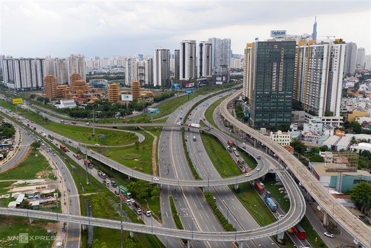
AsemconnectVietnam - Scope of direct research: the entire administrative boundary of Thu Duc city belongs to Ho Chi Minh City with a total area of about 211.56 km2.
Master plan of Thu Duc city in Ho Chi Minh City until 2040
1. Location, scope and boundaries of research:
Scope of direct research: the entire administrative boundary of Thu Duc city belongs to Ho Chi Minh City with a total area of about 211.56 km2.
Scope of indirect research: the districts of Ho Chi Minh City and 02 neighboring provinces, Dong Nai province and Binh Duong province.
Planning boundary: is the administrative boundary of Thu Duc city, 4 sides are adjacent to district-level administrative units as follows:
- The East is adjacent to Bien Hoa city and Long Thanh district, Dong Nai province;
- The West is adjacent to District 4, District 1, District 12 and Binh Thanh District, Ho Chi Minh City;
- The South is adjacent to District 4, District 7, Ho Chi Minh City and Nhon Trach District, Dong Nai Province;
- The North is adjacent to Thuan An city and Di An city, Binh Duong province.
2. Time limit for planning: until 2040.
3. Planning objectives and viewpoints:
a) Objectives:
- Proposing development orientations suitable to the structure and spatial development orientation of Ho Chi Minh City and the Ho Chi Minh City region; meet the goal of becoming one of the important economic, scientific, technological and financial centers of Ho Chi Minh City and the country.
- Meeting new requirements in the city's socio-economic development strategy; creating feasible conditions for the synchronous implementation of solutions to solve current urban development problems such as population, housing, infrastructure, traffic, environment, adaptation to climate change in the world, digital infrastructure development and transformation. Towards urban development with good quality of life and attractive working environment; have a typical culture on the basis of conservation of heritage and river landscape; develop smart, sustainable urban infrastructure and adapt to climate change.
- Create a legal basis for the management, development, investment and construction of urban technical infrastructure systems and areas in Thu Duc city according to the planning, ensuring urban quality according to urban standards I is under Ho Chi Minh City.
b) Point of view:
- In line with the city's socio-economic development strategy, national sectoral master plans, Ho Chi Minh City general planning and Ho Chi Minh City planning period 2021 - 2030, with a vision to year 2050.
- Inheriting and continuing to implement the basic orientations, the contents of the current general planning and other specialized plans in the area are still relevant. Effectively exploiting natural conditions and typical ecosystems of Thu Duc city for harmonious development between economy and culture - society, environmental protection, and climate change adaptation.
- Develop a strategic and feasible plan on the basis of proposed solutions, management mechanism and plan to implement the plan synchronously and in accordance with reality.
4. Urban characteristics:
- Being a grade I urban center directly under Ho Chi Minh City, developed according to the model of an innovative and highly interactive urban area; the eastern center of Ho Chi Minh City in terms of economy, science and technology and technology, culture, education and training.
- Being an innovation center based on knowledge economy, science - technology and development cooperation; focusing on the fields of higher education and training, high-tech research and production, finance and trade-services; plays the role of the nucleus in innovation and digital infrastructure development of the city and the Ho Chi Minh City region.
- As the focal point connecting the existing central area of Ho Chi Minh City with Long Thanh international airport and key urban areas and functional areas in the East of Ho Chi Minh City region.
5. Preliminary forecast of development indicators:
a) Population size:
It is expected that by 2030, the population of Thu Duc city will reach about 1,500,000 people; 2040 will reach about 2,200,000 people, aiming to 3,000,000 people after 2040.
b) Size of land:
- By 2030, it is expected that urban construction land will be about 18,830 ha;
- By 2040, it is expected that urban construction land will be about 19,994 hectares.
(The specific analysis, evaluation and forecast of population size and urban construction land in each period will be studied and proposed during the study of the planning project).
6. Key requirements for planning work
a) Review the general planning of Ho Chi Minh City and the specialized plans that have been implemented in Thu Duc city, on the basis of:
- Analyze and evaluate the implementation of the general planning of Ho Chi Minh City in 2010 in the area, focusing on the implementation of development orientations in the eastern urban area of Ho Chi Minh City with the role of is the newly expanded center of the city (Thu Thiem New Urban Area) and the Science and Technology Urban Area, the nucleus is the High-Tech Park and the National University Area. Identify new factors, shortcomings and problems in management and implementation.
- Review and evaluate projects and plans in Thu Duc city that have been formulated and approved; orientation of urban space development, land use planning, technical and social infrastructure with actual development trends in Thu Duc city.
b) Forecasting development needs in the new period, in the context of the development of Ho Chi Minh City and the provinces: Dong Nai, Binh Duong, Ba Ria - Vung Tau, ensuring that it is consistent with development practice , closely following the socio-economic development strategies, spatial development orientation of Ho Chi Minh City, the policy of developing highly interactive creative urban areas, smart cities, and sustainable urban areas.
Research and update important guidelines and orientations related to urban planning, development and socio-economic development; coordinate programs, schemes, projects... of the city in a development framework with a long-term vision and high performance.
c) Research on the urban background that has formed and developed over many periods, propose a model of Thu Duc city development in the direction of public transport development (TOD) associated with effective land use plan, creating more room for development from the value of the land and ensuring the ability to reserve for the future and protect the ecological environment.
d) Coordinate and agree on data, forecasts, development orientations and related contents with the planning process of Ho Chi Minh City for the period 2021 - 2030, vision to 2050 and sectoral plans , other specialized plans are being formulated at the same time.
Clarifying existing premises (geography, economy, infrastructure, human resources,...) and limitations in Thu Duc city as a major innovation center of Vietnam, is the place with the highest labor productivity in Vietnam, the nucleus of realizing the knowledge economy, the place where the 4th industrial revolution of Ho Chi Minh City and the southern region was realized, sustainable development in culture and environment, a center of finance and international integration of Vietnam. From there, propose major planning solutions to overcome these limitations.
7. Specific requirements on planning research contents
a) Collect documents and data and review urban standards and criteria:
- Sources of documents, data and information on the current status must ensure quality, reliability and clear sources; ensure the scientificity, sufficient quantity, and sufficient length of data series over time to serve analysis, evaluation and forecast work in the planning process.
- Review and assess the situation of socio-economic development, the current state of infrastructure and architecture, urban landscape, compare the criteria for assessment and classification of urban areas in Resolution No. 1210/2016/ UBTVQH13 dated May 25, 2016 of the National Assembly Standing Committee on urban classification to determine the criteria that need to be supplemented and perfected, according to the criteria of class I cities in the coming time.
b) Analyze and evaluate the context and current status of urban development:
- Assess location and regional relationship:
+ Analyzing the spatial relationship between Thu Duc city and neighboring urban areas in the provinces in Ho Chi Minh City such as Nhon Trach, Bien Hoa (Dong Nai), Thuan An, Di An (Binh Duong) and Phu My, Vung Tau (Ba Ria - Vung Tau),...; analyzing the relationship and impact of strategic works and projects on national and Ho Chi Minh City transport infrastructure on the development of Thu Duc city such as: Long Thanh International Airport, Cai Mep - Thi Vai Port and highway projects, ring roads, key infrastructure works according to national sector planning;
+ Assess the advantages and limitations of the geographical location of Thu Duc city. Analyzing the relationship between Thu Duc city and Ho Chi Minh City on the specificities, opportunities and challenges of the "city within city" model; clarify the connection and role of Thu Duc city with the central urban area of Ho Chi Minh City and other areas.
- Analyze the natural conditions and characteristics of the system of rivers and canals in the Dong Nai river basin and the natural values that need to be preserved and preserved in the development of Thu Duc city.
- Analyze and evaluate the current state of economy - society - environment through economic indicators and structure, especially high-tech manufacturing and financial services; digital economy; population characteristics, labor, employment, income, migration issues; indicators on environment, climate and impacts of climate change on urban areas.
- Analyze and evaluate spatial development orientation, land use planning, urban structure to clarify the characteristics of urban development: Analysis and assessment of the current state of land use. Analyze the distribution structure of main functions, landscape structure, urban gateway areas, system of centers, squares, functional areas in urban areas.
- Analysis and assessment of the current status of technical infrastructure and environmental protection, including: traffic, ground elevation and storm water drainage, energy, lighting, communication, water supply and wastewater drainage, solid waste management and cemeteries, environmental protection... within Thu Duc city. Identify the shortcomings, which need to be improved to meet the urban quality standards of grade I.
- Evaluation of plans and projects in the area that have been formulated and approved; update the national sector plans that are being implemented.
- General overview of the current state of urban development. Identify key issues to be solved, as a basis for proposing planning content and solutions.
c) Determining the characteristics, goals, motivations and targets of urban development:
On the basis of the nature of Thu Duc city, develop urban development goals according to the following criteria:
- Gradually improve the quality of existing functional areas that are the driving force of urban development such as: Thu Thiem new urban area, Vietnam National University Ho Chi Minh City, Ho Chi Minh City Hi-tech Park , Cat Lai port; at the same time, forming centers that are new development driving forces of urban areas to meet the requirements of the development of knowledge economy, science - technology, finance and trade - services.
- Completing the transportation system and information and communication infrastructure (ICT) to increase connectivity and interaction between existing dynamic functional areas and new centers to form a network of innovation centers. Innovative, pervasive, new driving force for socio-economic development, forming an urban infrastructure system in the direction of a smart and highly interactive city.
- Integrated urban development with the public transport system (TOD), other high-speed traffic, including public underground traffic and surrounding underground urban space, linking public transport with use land to effectively exploit land, expand urban development space, functional areas.
- Renovate and upgrade technical and social infrastructure in association with embellishment of existing residential areas, ensuring to meet demand and synchronize with modern new development areas. Preserve and enhance the spatial identity of urban landscape architecture; increase the public green land fund, improve the environment in the existing areas.
- Determining the system of urban development indicators: proposing the selection of economic - technical indicators; forecasting the impacts of natural conditions, socio-economic development, population size, urban construction land size and technical and social infrastructure in each development stage, ensuring suitable to development practice, feasible and synchronous with urban development targets of the whole Ho Chi Minh City.
d) Space development orientation:
Proposing a development model, urban spatial structure closely linked with the development model, spatial structure of the whole Ho Chi Minh City; consistent with the development plan of the national sector planning related to the spatial scope of Thu Duc city; suitable for an innovative and highly interactive urban model; connecting with key urban areas in the East of Ho Chi Minh City such as Bien Hoa, Nhon Trach, Thuan An, Di An, Phu My, Vung Tau, etc. Urban spatial development orientation needs to be studied on the basis of Based on the relationship and role of Thu Duc city with other key centers and functional areas of Ho Chi Minh City, with Long Thanh international airport, ring roads and key works of high quality. regions and countries that have an impact on the space of Thu Duc city; ensure a harmonious organization between functional areas that are the core of existing development with new driving force centers to form a network of centers to meet the requirements of knowledge-based economy development, science and technology, finance and trade - services. Urban space development needs to be suitable with the characteristics of topographical conditions, hydrogeology and capacity of technical and social infrastructure systems in each development area; sustainable development of the ecological environment, protection of natural ecological structures, conservation of biodiversity, ensuring resilience and resilience to changing impacts; associated with the roadmap of transforming districts into districts according to the orientation of the city's administrative units. The content of the spatial development orientation of Thu Duc city mainly includes:
- Urban development model and direction;
- Determining the scope, scale, orientation and development principles for each functional zone of the urban center; existing areas with restricted development, areas of embellishment and renovation, areas in need of conservation and embellishment; functional conversion zones; new development zone; construction-prohibited zones, development reserve zones; areas where underground works are expected to be built;
- Determination of population density, urban planning land use criteria, orientation and principles of land management and use for each area according to each development stage;
- Determining the location, scale, orientation and development principles for the system of administrative centers, commercial centers, service centers, public centers, physical training and sports centers, parks, trees and airspace; urban-level specialized centers;
- Determining the areas where underground works are expected to be built: underground works system; location and scale of multi-purpose underground works complex; propose key areas that need to be planned for urban underground construction space and propose requirements and principles for development management, exploitation and use of underground space;
- Identify architectural regions, landscapes, central areas, gateway areas of the city, main spatial axis, large squares, green space, water surface, urban highlights and proposals principles and requirements for the organization of space and architecture for the above areas and urban design contents as prescribed.
d) Development orientation of urban technical infrastructure and services:
- Focus research requirements:
+ Evaluate and compare technical infrastructure and urban environment indicators with regulations on criteria and criteria for urban classification and the project on establishing Thu Duc city to propose solutions to renovate, complete the city's technical infrastructure system to ensure the quality of a class I city, meeting the goals of green, sustainable and smart city development;
+ Research and propose a framework technical infrastructure system of the city in accordance with the content of current sectoral master plans in accordance with the planning law, consider synchronously the development stages and ensure adaptation to changes. Research and propose the development of technical infrastructure, especially communication, as a basis for building solutions for intelligent technology application in urban infrastructure development and management;
+ Proposing solutions to overcome the overload and inadequate connection of the technical infrastructure system in urban areas and with Ho Chi Minh City, especially in terms of traffic infrastructure; reduce the impact of urban environmental problems. Researching the link between public transport and land use to effectively exploit land, expand urban development space and functional areas;
+ Proposing solutions to orient the development of fire prevention and fighting infrastructure in the planning period for the planned objects (including: water supply system, traffic, communication, headquarters network, barracks, works in service of fire prevention and fighting).
- Main research contents:
+ General assessment and selection of urban development land: assessment of topography, geological hazards, identification of areas where construction is prohibited or restricted;
+ Traffic: forecasting demand for passenger and cargo transportation. Determine the external traffic network, urban traffic, ensure traffic density according to standards, create a complete network, create conditions for the development and expansion of the public transport network, effectively solve traffic jams; strengthen the connection between innovation centers, between Thu Duc city and other areas of Ho Chi Minh City and with neighboring provinces. Determining the location and scale of major traffic works such as seaports, river ports, railway stations, foreign bus stations; determine the red line boundaries of the main urban axes and the system of trenches and technical tunnels. Organize the public transport system and the system of stations and parking lots to ensure that public transport meets 50% - 60% of travel demand, and by 2040, the density of the public transport network will reach 2.5 - 3.0 km/km2; reaching the target of 50 ÷ 60 km of rapid public transport with large capacity/million people.
- Ground elevation and rainwater drainage: Proposing orientations to improve ground level and surface water drainage in the whole urban area, taking into account the dual effects of ground subsidence and climate change. Proposing solutions for leveling to create construction ground, increase permeable surface area and increase water storage capacity before discharging to drainage; identifying spaces for water storage, integrating the planning of ground elevation and surface water drainage with the protection of river systems, wetlands and green areas. To divide water drainage basins, determine the location and scale of water drainage works and rainwater drainage systems appropriately, separate from the wastewater drainage system. Determine the elevation of the construction foundation for areas according to the drainage basin, ensure control of inundation caused by rain, high tide and ensure flood drainage; uniformly and synchronously with the planning of irrigation against inundation (in line with regional planning, city construction planning).
- Communication: determine the location and size of the focal works and the main distribution network of the communication system in each period to ensure the service of socio-economic development, urban development and socio-economic development. Proposing principles on management and organization of undergroundization and common use of telecommunications network infrastructure; developing digital infrastructure towards the goal of developing the digital economy, realizing the breakthrough goal of city management and building digital government.
- Power supply and lighting: forecast of electricity load demand and other energy use demand; determining energy supply sources (including proposing solutions to use clean and renewable forms of energy), locations and sizes of focal works and main distribution networks of the energy supply and lighting system in stages; ensure consistency and synchronization with the system of works, electricity transmission and distribution network in the national electricity planning and other energy planning.
- Water supply: forecast water demand for the whole urban area and according to urban areas, ensure the flow, pressure of water supply, amount of water stored for daily life, production and fire prevention. Proposing a strategy for clean water and water security. Define design criteria and standards. Evaluation and selection of water supply sources (diversification of water supply sources, ensuring supply for the city's population); formulating plans for water supply and water use in an economical and efficient manner; selection of water treatment technology, reuse of water resources. Determine the location and size of the focal works and the main distribution network of the water supply system in each period. Proposing measures to protect water sources and water supply works.
- Sewage drainage: forecasting demand for wastewater drainage; determine the location and scale of key works and the main distribution network of the wastewater drainage system in each period, ensuring consistency and synchronization with the city's drainage master plan. Proposing orientations, planning solutions towards reuse of wastewater and water quality requirements for different types of wastewater after treatment.
- Management of solid waste and cemeteries: forecasting demand for solid waste treatment and cemeteries. Determining the location and scale of the main treatment works and the main network of solid waste collection in each period; location and size of cemetery. Proposing requirements and measures for environmental management for focal works of solid waste collection and treatment and cemeteries.
- System of works serving logistics.
e) Orientation to develop the socio-cultural infrastructure system including general education, vocational secondary school, health care, entertainment, sports, theater, square.
On the basis of assessing the status of distribution and development of social infrastructure, reviewing the criteria that are lacking compared to the criteria of class I cities, proposing solutions to upgrade and complete the socio-cultural infrastructure. Analysis of needs, connectivity and support of the city model in a centrally run city, forecasting economic - technical indicators; propose solutions to build new and renovate functional zones (national level, provincial level, urban level).
g) Financial and commercial infrastructure: including an international financial center system, an exhibition center, a system of supermarkets, traditional markets and a retail network.
h) Knowledge-based economic infrastructure: it is necessary to supplement the development of knowledge-based economic infrastructure, form a creative ecosystem connected to production, service and cultural activities in Ho Chi Minh City, on nationally and internationally. To form international-level university zones, Quang Trung - Thu Duc Artificial Intelligence and Software Park, Hi-Tech Parks and Hi-Tech Applied Industrial Parks, Technology Research and Experiment Centers.
i) Strategic environmental assessment: strategic environmental assessment including the natural and social environment, according to the climate change response scenario and sea level rise integrated with the land subsidence in the area. Develop solutions to protect the environment, recommend land use, urban structures, mechanisms, policies, and resources, in order to minimize damage in case of natural disasters or negative impacts on society. The strategic environmental assessment is carried out in accordance with the law on environmental protection.
k) Priority investment programs and projects and resources for implementation:
- Investment phase: identify priority investment programs and projects for each period in order to concretize objectives and list of key state projects that need investment and call for investment.
- Proposing mechanisms, policies and solutions to organize the implementation of the plan: build a scientific and practical basis in determining resources, propose mechanisms and policies to mobilize and effectively use resources.
l) Formulate management regulations according to the general planning project:
Proposing project-based management regulations, including general and specific regulations for each area.
8. Other requirements in the planning process:
The general planning of Thu Duc city needs to be unified and synchronized with the Adjustment of the general planning of Ho Chi Minh City, the planning of Ho Chi Minh City in the period of 2021 - 2030, with a vision to 2050 and plans with other specialized technical properties.
In order to improve research quality and feasibility, in addition to the requirements specified in the Law on Urban Planning, Decree 37/2010/ND-CP and Circular 12/2016/TT-BXD, in the process of organizing Planning authorities should note:
The planning needs to be unified and synchronous (on regional linkage, land use planning, development direction of key sectors and fields compatible with socio-economic development targets).
Applying geographic information technology - GIS to analyze and evaluate urban development trends over time in order to propose planning solutions suitable to the characteristics of urban areas in Ho Chi Minh City and Thu Duc city. The GIS database is transferred to the state management agency for development forecasting and digital transformation in urban planning and management.
Urban design: meeting the requirements of Circular 06/2013/TT-BXD and 16/2013/TT-BXD. Encourage the use of modern technology to simulate urban structure and urban spatial development direction according to the proposed options.
Have a plan, a working mechanism to coordinate with the leading agencies, other relevant planning consulting units, projects, programs and schemes of Ho Chi Minh City for coordination, Update closely and synchronously.
Develop a framework to evaluate the implementation of the plan (in the period 2030, 2040), creating a basis for specialized agencies to monitor and promptly adjust (if any) regulations, mechanisms and policies in management, effective and scientific urban planning and development, meeting the State's policy on administrative reform and smart urban construction.
9. Ingredients, product profile:
Profile of the general planning project of Thu Duc city of Ho Chi Minh City until 2040 in accordance with current legal regulations. Drawings are shown on the map background of 1/10,000 scale for maps assessing the current status, spatial development orientation, technical infrastructure and land use; expressed in appropriate proportions for drawings showing the analysis of regional relationships, strategic environmental assessment and other contents.
10. Implementation organization:
- Level of approval: Prime Minister.
- Appraisal agency: Ministry of Construction.
- Agency for approval: People's Committee of Ho Chi Minh City.
- Planning organization: People's Committee of Thu Duc city.
- Planning consulting agency: selected according to regulations.
- Project preparation time: no more than 12 months.
Source: Vitic/ thuvienphapluat.vn
Program on conservation and development of Vietnamese craft villages in a period of 2021 - 2030
Implementation plan of marine aquaculture development project in Ninh Binh province to 2030 with a vision to 2045
Plan on implementing national environmental protection strategy to 2030 with a vision to 2050 in Kien Giang province
Plan on implementing Decision No. 327/QD-TTG dated March 10, 2022 of the Prime Minister approving the project on developing sustainable and effective wood processing industry in the period of 2021-2030 in Gia Lai province
Action plan on implementing strategy of sustainable agricultural and rural development in a period of 2022-2030 with a vision to 2050 in Hanoi city
Plan on implementing Decision No.923/QD-TTG dated August 2, 2022 of the Prime Minister approving science and technology program for new rural construction in a period of 2021-2025 in Vinh Long province
Plan on implementing strategy of sustainable agricultural and rural development in Bac Kan province in a period of 2021 - 2030 with a vision to 2050
Action plan on implementing livestock development strategy in a period of 2022-2030 with a vision to 2045 in Hanoi city
Implementation plan of Vietnam's forestry development strategy for a period of 2021-2030 with a vision to 2050 in Gia Lai province
National master plan in a period of 2021-2030, vision to 2050
Program on strengthening environmental protection, food safety and rural clean water supply in building new countryside in a period of 2021-2025
Digital transformation program on building new countryside, towards smart new countryside in a period of 2021 - 2025
Rural tourism development program on new rural construction in a period of 2021 - 2025
Project on development of trade, e-commerce systems and border trade in Binh Phuoc province in a period of 2021-2025, orientation to 2030
Plan on implementing Decision No. 327/QD-TTG dated March ...
Concretize viewpoints, objectives, tasks and solutions of the plan in accordance with practical conditions of the locality, associating ...Plan on implementing national environmental protection ...
Implementation plan of marine aquaculture development ...
Program on conservation and development of Vietnamese ...
Plan on improving quality of human resources to 2025 and ...

Efforts taken to turn culinary culture into national ...
The Vietnam Cuisine Culture Association (VCCA) is taking steps to implement a project to build and develop Vietnamese culinary culture ...Vietnamese cuisine making a name for itself with ...
Vietnam advance to next round of AFC U20 Women’s Asian Cup
Cultural tourism and traditional values promoted through ...
